- The evolution of maritime buoyage from inconsistent national systems to the globally standardised IALA system (Regions A and B) developed after fatal accidents in the 1970s.
- Types of Navigation Marks: The six IALA buoy types (Lateral, Cardinal, Isolated Danger, Safe Water, Special, Emergency Wreck), their day/night identifiers, shapes, colours, and light rhythms.
- How to identify marks via visual, chart, and light characteristics; includes tips on interpreting light rhythms, sector lights, leading lines, and use of modern aids like the AMC buoyage app.
Knowing your navigational marks
Quick overview
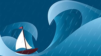
Whenever I’m out on Tasmania’s Tamar River, Australia’s longest navigable estuary at about 40nm (70km), I wonder at the challenges that early seafarers faced as they manoeuvred through the shoals on square-rigged ships. In those days, and right up until the 1930s when radar came onto the scene, visual navigation was the only kind of navigation available.
As late as 1889, no effort had been made to create any kind of unified system of buoyage. While some consistency was achieved over the next 80 years, particularly by the League of Nations in 1936, more than 30 countries that weren’t signatories to the convention persevered with their own systems.
After the re-establishment of buoys throughout Western Europe after World War II, based on that 1936 convention, no fewer than nine different systems still remained in that region as countries interpreted the convention differently – so merchant shipping, captains and their crews still had this navigational mess to contend with.
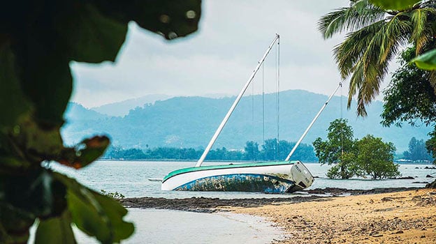
In 1971, the merchant ship Brandenburg sank in the English Channel just minutes after striking a recent, well-marked wreck and was followed weeks later by the Niki. In all, 51 lives were lost, and it finally spurred a determined effort to achieve global uniformity.
How the navigation aid system works
In the 1970s, the International Association for Lighthouse Authorities (IALA) – now known as the International Association for Aids to Navigation – set out to develop a standardised system for buoys and other marine navigation aids.
It committed to dividing the world into two regions, imaginatively named A and B. The only difference was lateral marks (often referred to as channel marks), whereby in Region A the starboard marker is green and the port marker is red when proceeding upstream or coming into harbour – in Region B, port is green and starboard is red.
Region A includes Africa, most of Asia, Australia, Europe and India, while Region B includes North, Central and South America, Japan, Korea and the Philippines.
There are six types of marks in the maritime buoyage system that can be used alone or in combination, and they may be fixed or floating:
- Lateral marks (there are four variants)
- Cardinal marks (also with four variants)
- Isolated danger marks
- Safe water marks
- Special marks
- Emergency wreck mark.
How to identify navigation markers
By day, marks can be identified by their structure, general shape and top mark if one is fitted. For example, a beacon is usually a fixed mark, driven into the seabed or a bordering shoreline or fixed onto a reef. It might carry a top mark.
A pillar or spar is a floating mark that usually carries some sort of structure upon which a top mark is mounted. A buoy is usually a minor mark of a particular shape but does not carry a top mark.
By night, marks are identified by their colour and the rhythm of their light – but beware, not all marks are lit. Lights are sometimes also enhanced by specific retro reflectors on the structure.
On electronic navigation charts, lit marks are identified by a teardrop shape that may vary in colour, while on paper charts, the teardrop is coloured magenta (purple) to show up well under the red light of a chart table.
Navigational light sequences
What do you call it when a light blinks on and off? Your first answer might be ‘flashing’, but that’s only partially right in maritime buoyage terms.
The IALA defines the light rhythms of marks very specifically:
- A flashing light has a longer period of darkness than light
- An occulting light has a longer period of light than darkness
- An isophase light has equal periods of light and darkness.
You can also recognise the light characteristics on navigation charts by comparing the light you see with the descriptions on the chart.
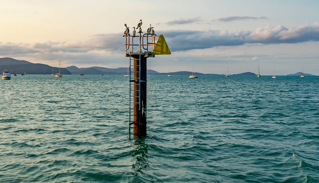
Lateral marks
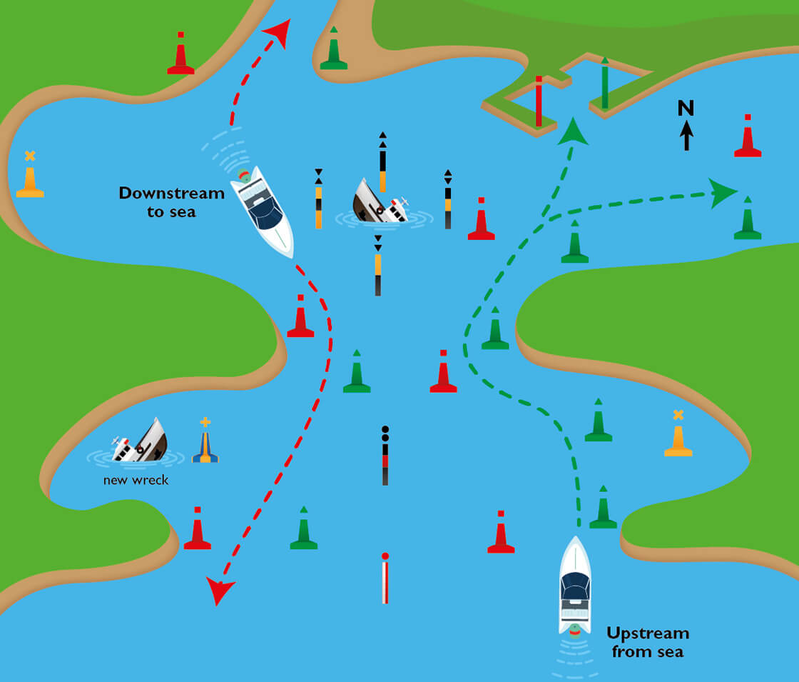
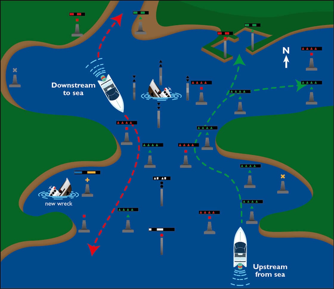
Lateral or channel marks indicate the sides of a channel or body of navigable water to starboard or port. The direction of buoyage is the path of safe navigation when heading into a port, upstream into a river, or generally toward a shoreline, with the red port mark on the boat’s left side and green starboard mark on the right.
In the case of an isolated land mass farther offshore, marks are laid according to a clockwise direction of travel around it – so, when travelling up a river, pass the green marks on your boat’s starboard (right) side, and the red marks to your port (left) side. When travelling in the other direction toward the sea, do the opposite.
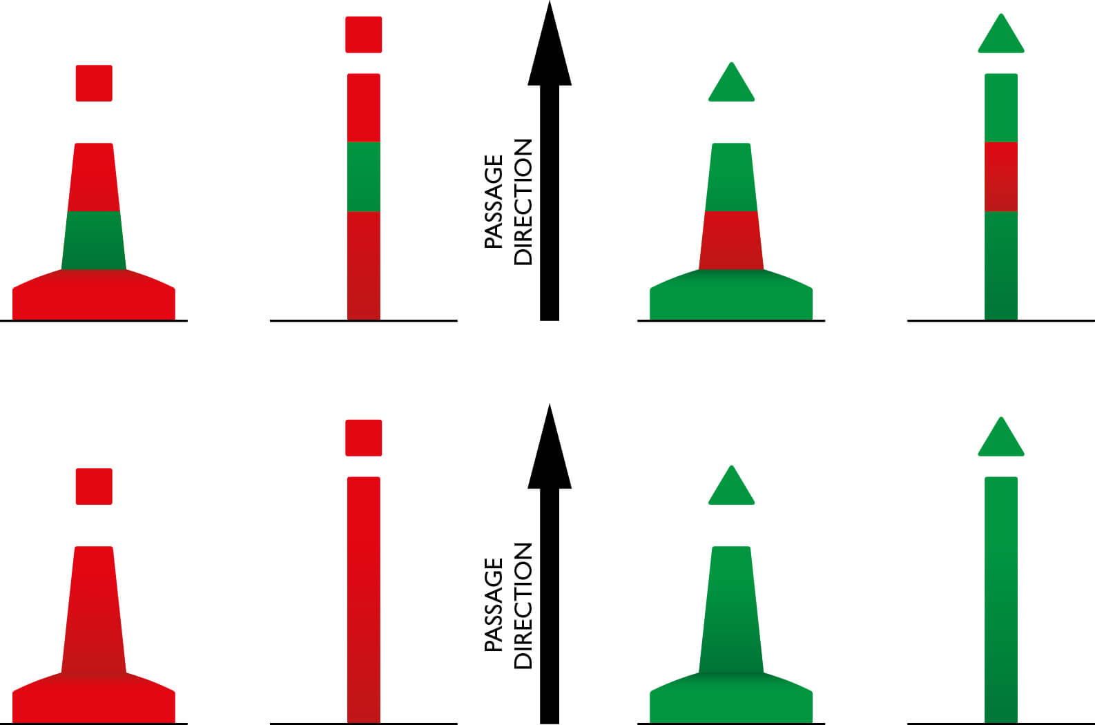
Starboard lateral marks have a cone-shaped top mark but they’re not always fitted to larger pillar-style marks. They’re green and, by night, have a green light that can display any rhythm except a composite flash of two followed by a single flash, which is reserved for a different type of lateral mark called a preferred channel mark … these are very rare in Australia.
A port lateral mark is red, carries a red top mark shaped like a can, and otherwise has the same light characteristics. A minor buoy will be in the shape of a green cone or a red can.
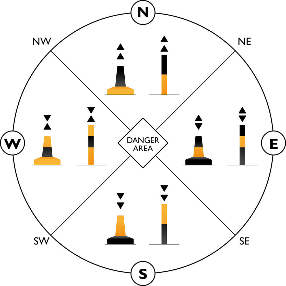
Cardinal marks
Named for the cardinal points of the compass, with each name indicating the direction of safe water, this group of four marks can be recognised by day by the orientation of their conical top marks, as well as the order of their black and yellow horizontal bands on the structure.
The easy way to remember them is to follow which way the apex of the cones point, and to align that with the position of the black bands. The cones on east look like an egg, and west looks like a wine glass.
By night, cardinal marks all show quick (about 60 per minute) or very quick (about 120 per minute) flashing white lights, with each one using a different sequence – beginning with the north mark’s continuous flash, the other three can be remembered by comparing it with a clock face: three, six and nine flashes.
At the end of the south mark’s group of six flashes you’ll see a long flash of two seconds, which is to ensure that it won’t be mistaken for a group flash of three (east) or nine (west).
Where two or more cardinal marks are used in close proximity, the flashing rate should be dissimilar to avoid confusion.
You will need your compass to use these marks effectively, or at the very least change your chartplotter’s orientation to ‘north up’ and not ‘head up.
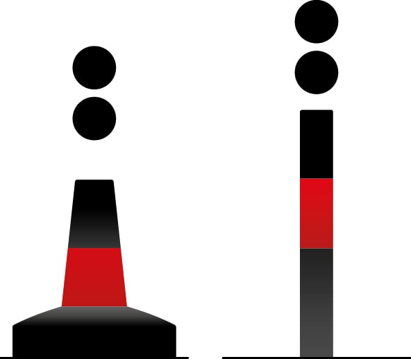
Isolated danger marker
These marks are easy to understand as they’re always placed or moored above an isolated danger that has navigable water all around it.They don’t have a distinctive shape but are usually a pillar or spar, and will always be black with one or more horizontal red bands and a top mark of two vertical black spheres.
A white light, flashing in groups of two (abbreviated as Fl(2) on a chart) distinguishes this mark at night from any of the cardinal marks, or the sequence options belonging to a safe water mark.
Safe water mark
One of the more difficult marks to memorise is the safe water mark, as it has four different light rhythm options and, as the name indicates, isn’t used to mark a danger but rather to indicate that it has navigable water all around it.
Typical applications for this mark include indicating mid channel, or maximum overhead clearance under bridges or powerlines.
Safe water marks are spherical when a floating buoy is used, or otherwise pillars, spars or beacons painted with vertical red and white stripes, and fitted with a single red spherical top mark.
The hard bit is remembering the four possible rhythms of white light that they may show: isophase (Iso), occulting (Occ), Morse Code Alpha (Mo(A)), or one long flash every 10 seconds (LFl 10s).
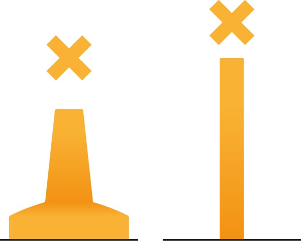
Special marks
These marks are not intended to mark channels or obstructions where the IALA buoyage system provides suitable alternatives, but they’re still quite common because they mark special areas or features whose nature will become apparent when you reference your nautical chart.
Special marks are always yellow, but their actual buoy shape can vary, including cans, cones or spherical shapes, according to their purpose. The top mark is always a three-dimensional yellow St Andrews Cross shape … an X.
- Some examples of their use include:
- Spoil ground areas
- Underwater cables, pipelines or outfall pipes
- Exclusion zones, or anchorage boundaries
- Aquaculture structures.
By night, a lighted special mark can have any rhythm of yellow light that is not used by a white light elsewhere in the buoyage system, to avoid confusion. For example, a group of four yellow flashes (Fl(4)) is common, as no other mark with a white light exhibits this rhythm.
Emergency wreck mark
While not really a common sight, these marks are deployed temporarily to indicate a wreck that presents a danger to navigation. The have distinctive yellow and blue vertical stripes, with a yellow cross as a top mark.
By night, they display an alternating yellow and blue light lasting one second, with a half second of darkness between.
Other marks used for visual navigation
Sector lights are usually beacons on shore that project an arc of light seaward, through sectors, or divisions in the housing of the light itself. While these vary enormously, a typical arrangement would be a white sector to show safe water, a red sector to show that a vessel is too far to port, and a green sector to show it is too far to starboard.
Leading lines, sometimes known as transit marks, have a very similar function and are common around estuaries or busy port environments to assist larger ships while piloting confined or high-risk waterways. So long as these beacons are in line, you’re on the safest course.
By night, leading lines, if lighted, will often display a fixed light, such as these examples shown on a paper chart.
The Australian Maritime College (AMC) has developed an app to help understand the meaning of each buoyage marker, with full 3D visuals of the type of buoy, colour, shape and lighting sequence. Find the ‘AMC Buoyage System (IALA)’ app on Google Play or in Apple App Store.
RELATED ARTICLES


Any advice here does not take into account your individual objectives, financial situation or needs. Terms, conditions, limits and exclusions apply. Before making a decision about Club Marine boat insurance, consider theProduct Disclosure Statement (PDS)/Policy Document and Supplementary PDS (if applicable). Where applicable, the PDS/Policy Document, Supplementary PDS and Target Market Determination (TMD) for Club Marine boat insurance are available on this website. We do not provide any form of advice if you call us to enquire about or purchase a product.
Club Marine Limited (ABN 12 007 588 347), AFSL 236916 issues Club Marine boat insurance and handles and settles claims as agent for the insurer Allianz Australia Insurance Limited (ABN 15 000 122 850) AFSL 234708 (Allianz). Club Marine Limited is a related body corporate of Allianz. Copyright © 2026 Allianz Australia Limited.